

How to Join Backcountry Ski - Beta App Beta on iOS

About Backcountry Ski - Beta App
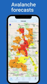
All your backcountry weather and avalanche data concisely displayed on one map
Easily review all the essentials before heading out on a tour:
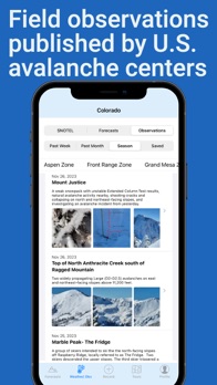
Avalanche forecasts and field observations from 14 major avalanche centers including Colorado Avalanche Information Center, Utah Avalanche Center, Teton Avalanche Center, Mount Washington Avalanche Center and more.
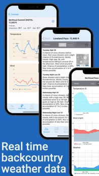
Real-time temperature, wind and snowfall data from 2,000+ mountain weather stations
Weather networks include SNOTEL, MADIS, CoCoRaHS, CWOP and many others.
Hourly NOAA weather forecasts for your summit objective.
Trip planning tools designed for backcountry skiers and snowboarders:
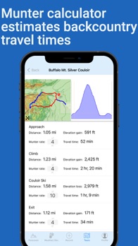
Munter calculator estimates ski tour travel times based on distance and vertical climb.
Create instant trip plans from your GPX tracks
Share route information, weather, avalanche forecasts and safety checklists with your partners.
Topographic slope maps highlight high-risk avalanche terrain.
GPS tracking to record and share your tours.
Built for the backcountry:
Offline topo maps work without cell service.
Home Screen widgets for quick weather and avalanche updates.
All your backcountry resources displayed on one user-friendly map.
What Backcountry Skiers Are Saying:
"It's amazing to have all these tools packed neatly into one app..
Finally!!!"
"All the weather/snow-nerd data - it's all here."
"A wealth of resources for backcountry skiers...this is my go to app."
"Having NOAA point forecasts, avalanche outlook, and SNOTEL data all in one app is just the best
This is THE essential winter recreation app IMHO."
===============
Offline topo maps, hourly weather forecasts, weather station data and munter calculator require pro subscription or $19.99 one time lifetime purchase
Subscriptions may be managed and auto-renewal may be turned off through the app's profile tab or from your iTunes account.


